


03 White Pine School Voting District, Jefferson County, Tennessee
About
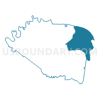
Outline

Summary
| Unique Area Identifier | 668915 |
| Name | 03 White Pine School Voting District |
| County | Jefferson County |
| State | Tennessee |
| Area (square miles) | 44.26 |
| Land Area (square miles) | 38.83 |
| Water Area (square miles) | 5.43 |
| % of Land Area | 87.73 |
| % of Water Area | 12.27 |
| Latitude of the Internal Point | 36.08528150 |
| Longtitude of the Internal Point | -83.29885670 |
Maps


Graphs
Select a template below for downloading or customizing gragh for 03 White Pine School Voting District, Jefferson County, Tennessee


Neighbors
Neighoring Voting District (by Name) Neighboring Voting District on the Map
- 01 Dandridge Elementary Voting District, Jefferson County, TN
- 08 Old Swannsylvania School Voting District, Jefferson County, TN
- 09 Talbott School Voting District, Jefferson County, TN
- 10-2 Union Heights Voting District, Hamblen County, TN
- 11-1 West High School Voting District, Hamblen County, TN
- 11-2 Witt School Voting District, Hamblen County, TN
- Edgemont Voting District, Cocke County, TN
- Rankin Voting District, Cocke County, TN
Top 10 Neighboring County Subdivision (by Population) Neighboring County Subdivision on the Map
- District 3, Jefferson County, TN (7,516)
- District 1, Jefferson County, TN (5,849)
- District 4, Cocke County, TN (5,487)
- District 3, Cocke County, TN (5,071)
- District 8, Jefferson County, TN (5,052)
- District 9, Jefferson County, TN (4,840)
- District 10, Hamblen County, TN (4,636)
- District 11, Hamblen County, TN (4,463)
Top 10 Neighboring Place (by Population) Neighboring Place on the Map
Top 10 Neighboring Unified School District (by Population) Neighboring Unified School District on the Map
- Hamblen County School District, TN (62,544)
- Jefferson County School District, TN (51,407)
- Cocke County School District, TN (28,717)
Top 10 Neighboring State Legislative District Lower Chamber (by Population) Neighboring State Legislative District Lower Chamber on the Map
- State House District 17, TN (67,337)
- State House District 11, TN (63,426)
- State House District 10, TN (62,544)
Top 10 Neighboring State Legislative District Upper Chamber (by Population) Neighboring State Legislative District Upper Chamber on the Map
Top 10 Neighboring 111th Congressional District (by Population) Neighboring 111th Congressional District on the Map
Top 10 Neighboring Census Tract (by Population) Neighboring Census Tract on the Map
- Census Tract 707, Jefferson County, TN (7,196)
- Census Tract 701, Jefferson County, TN (6,991)
- Census Tract 9202, Cocke County, TN (5,988)
- Census Tract 1007, Hamblen County, TN (5,906)
- Census Tract 1011, Hamblen County, TN (5,229)
- Census Tract 702, Jefferson County, TN (4,751)
- Census Tract 709, Jefferson County, TN (4,352)
- Census Tract 1008, Hamblen County, TN (3,233)